Emergency Access Route: Current Information
Most Recent FAQs:
Frequently Asked Questions (FAQs)
The following FAQs update the GFPD on progress toward the Emergency Access Route and respond to questions raised in GFPD-wide community meetings held from September 2022 to April 2024. We held two informational meetings in February and April 2024. Additional informational meetings will be scheduled in the next few months as we finalize next steps with the route and ballot measure. If you have specific questions not addressed in these FAQs, please email info@geneseefire.org.
Questions Related to the Value of Building an Emergency Access Route?
A secondary access road was recommended in the 2008 Community Wildfire Protection Plan (CWPP); the CWPP was updated in 2021 and this analysis, as well, documented the evacuation challenges in the district. The addition of a secondary ingress/egress route is a critical tool that, when coupled with roadway mitigation, increases roadway survivability for both residents and first responders, provides a secondary means of egress when a primary evacuation route is compromised, provides an ingress route for emergency responders, and gives firefighters the ability to defend GFPD from a fire approaching from the south/west, because the road gives them a safe way to escape should fire conditions warrant it. The GFPD Board of Directors supported Genesee Foundation’s conducting an engineering study to evaluate the feasibility of and formulate a cost estimate for a purpose-built road in the southern part of the GFPD. The GFPD has signed easements with both the Genesee Foundation and the Genesee Water & Sanitation District that will allow the GFPD to build and maintain the proposed Emergency Access Route without the need to purchase property. This is a benefit that few, if any, communities have when they consider a needed secondary route.
The Emergency Access Route will provide Genesee Fire Rescue and emergency responders with much greater flexibility in operational decisions as they respond to protect lives and property in the district. There are an infinite number of wildfire and other emergency scenarios. Each would dictate a unique strategy and a set of corresponding tactics but, for the sake of illustration, the following three examples illustrate how the Emergency Access Route might be utilized during a wildfire:
A wildfire approaching from the south or southwest: residents would be evacuated to the north and the Emergency Access Route would be utilized for ingress/egress of firefighting resources and/or as a place where firefighters can defend the District from an approaching fire (without the Emergency Access Route, the lack of an escape route would limit the ability of firefighters to operate in this areas). Law enforcement may elect to allow residents to use one or two lanes on Genesee Ridge and Genesee Trail Roads for egress and, if needed, they may shut down I- 70 to allow for the high volume of vehicles entering the highway.
A wildfire approaching from the west or east aiming for the midpoint of the District: a fire like this would likely cut the district in half in terms of fire operations and evacuation, blocking travel between the northern and southern parts of the district. As such, residents that would evacuate to the north if their route wasn’t blocked; those who could not access the existing route would use the Emergency Access Route. First responders would enter both from the north and the south.
A wildfire approaching from the west, northwest, north, northeast, or east in the upper portion of the district: If access to I70 was blocked or unsafe because of the fire, all residents would evacuate to the south on the proposed Emergency Access Route. First responders would enter the community from the north.
Again, there are numerous scenarios but, when possible, residents would be routed to the north. The reason for this is that during high stress/low visibility situations, following a familiar path is safer and much more likely to get residents out of harm’s way in the most efficient manner.
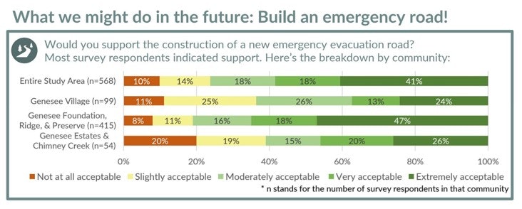
In 2021, a household survey was conducted for the GFPD and one of the questions asked was, ‘Would you support the construction of a new emergency evacuation road?’ ’ Those results are depicted below:
Letters of support from the Colorado Division of Fire Prevention & Control, the Jefferson County Sheriff Office, Highland Rescue Team, and Evergreen Fire & Rescue are on our website.
Questions Related to Technical Design of the Route
The Emergency Access Route is just over a mile long. The road is proposed to be twenty-four feet wide, consisting of two 9-foot travel lanes with 3-foot-wide shoulders on either side. The proposed road is a two-lane natural surface road designed to allow both two way and one way traffic in and out of Genesee. Three lanes were not considered because of cost (i.e., much more material to excavate, both rock and soil), a two-lane is considered more than adequate for ingress and egress by cars and fire equipment, and maintenance of speed at choke points. Curves will be widened to accommodate fire apparatus. The design accommodates a 20-mph speed and fulfills Jefferson County standards.
Referring to the Site Plan, the Emergency Access Route starts at elevation 7100 at the tennis courts and intersects Highway 74 at elevation 6612, a vertical drop of about 488 feet. The approximate distance along the Emergency Access Route alignment is 5900 feet. We investigated an additional segment that extends to E. Montane but decided against it since the extension adds 1200 feet of route length, 100 feet of elevation and an estimated half million dollars to the cost.
The Emergency Access Route will be an unpaved, natural surface road. An unpaved road does not affect fire apparatus usage. There are unpaved roads throughout Jefferson County that take , unlike the proposed route, heavy daily traffic with only infrequent maintenance (typically grading and compacting every several years). We have excellent soil conditions, so a professionally designed and constructed unpaved road and drainage system is a viable option. Paved roads, particularly on slopes, required annual crack filling to protect them from freeze-thaw. Unpaved roads, with less impervious surfaces, result in less stormwater runoff than paved roads. Paving the road adds about an estimated quarter million dollars to the cost. Finally, unpaved roads are aesthetically more compatible with our mountain community.
We have attempted to stay as far away from private property lines as we could. The narrowest point along the proposed route is between the expanded Reservoir 1 and Daisy Lane, with no feasible way to get further away from private property. Depending on the exact alignment, Emergency Access Route will be between 75 and 100 feet from the western point of Parcel 40- 303-01-028, 2397 Daisy Lane. Since this area is heavily forested, there must be additional mitigation (tree cutting) on Genesee Foundation Open Space property to make the route survivable. This is in a cut section (the road will be lower than the existing ground surface), so that may make the road a bit less noticeable from Daisy Lane.
At this point, none, although we have been informally told by CDOT that GFPD will get a permit for the Emergency Access Route. Until there is a finalized plan, we cannot submit for a permit. However, Highway 74 is not a restricted access road. There are numerous private driveways, public intersections, and parking lots that abut Highway 74 between Evergreen and Morrison. We have sited the intersection on the straightest section of the Highway in the Study Area, with the longest lines-of-sight. It is unlikely that CDOT would not permit an intersection for a project that is so much in the public interest.
Under the agreed upon easement, the Genesee Fire Protection District is responsible for constructing and maintaining the road. The road design includes mitigation to make it survivable during an evacuation event. Since the route is on Genesee Foundation open space, fire mitigation along the road is likely to be handled by the Foundation.
We have not discussed this with the Water District, but it is certainly worth investigating.
We have received unanimous approval of our plan from Jefferson County Planning and Zoning and are now in final design. Part of that design is coordination with both Jefferson County Engineering and the Colorado Department of Transportation on permit requirements. The design team has been through the first round of comments for a Jeffco Land Disturbance Permit and will be submitting for a CDOT permit for the intersection at Highway 74 in the near future. We are demonstrating adequate storm water management provisions, so we do not impact areas downstream. We are also in coordination with the Corps of Engineers and US Fish and Wildlife Service for appropriate permits. We are confident that the project will be permitted and shovel-ready before the May Special Election.
General consideration was given to environmental impact, but no specific study was undertaken. Since there are no wetlands, cultural history, or unique vegetation present in this area, no environmental constraints are recognized currently. If issues are raised during the permitting process we will update this FAQ.
The reservoir presents an asset to accommodate, but the feasibility study indicates that there is enough accessible area next to the reservoir and we can safely avoid any impact on the reservoir.
Questions Related to the Uses of the Route
The proposed Emergency Access Route is designed and constructed to be safely navigated by passenger vehicles, law enforcement vehicles, and fire apparatus during an emergency. The Emergency Access Route will not be used for public transport, recreational, or other day to day use by any person or entity and is intended to be used only for emergency ingress and egress, maintenance/mitigation, and as well as periodic training for firefighters and law enforcement personnel.
The Emergency Access Route will be access-controlled with appropriate gates and security, as well as appropriate signage, locks, and monitoring. The gates at either end of the route will be controlled by the Genesee Fire Protection District and the Jefferson County Sheriff Department. In the event of an emergency, the Jeffco Sheriff would control usage and the exit to Highway 74.
As per Jefferson County requirements, the Emergency Access Route will be a road controlled by GFPD, in accordance with the terms of easement agreements between GFPD and Genesee Foundation and Genesee Water & Sanitation District. Under the terms of the easement agreements, the route will only be used for ingress and egress by emergency vehicles, community residents in case of a wildfire emergency, and periodic fire department and law enforcement training.
Questions Related to the Cost, Funding and Timing Construction of the Emergency Access Route
The GFPD Board of Directors has the final say on a financing plan. The current plan is to have a TABOR election in May 2025 to request approval for a mil levy increase to fund the building and maintenance of the Emergency Access Route. All residents of the Genesee Fire Protection District would have the opportunity to vote on the measure and will have the final word, based on the vote.
The tax increase is dependent on whether we can identify any sources of funding that would offset the total amount we need to finance. Initial attempts have been unsuccessful, but we will again pursue this once we have a final plan and cost estimate. The property tax increase also depends on the length of bond financing we choose. Longer financing will decrease the mil levy increase and will spread the cost among current and future residents of GFPD; however, it also means that the total cost (principal plus interest) will be higher. As an example, assuming that we had to finance the entire project at a rate of 5.25%, a 10-year loan would mean an annual property tax increase of $68.33 per $100,000 assessed value with a total loan payback of approximately $10.5 million; the same loan paid back over a 20 year period would increase property tax by $42.91 per $100,000 assessed value and the total loan payback would be a little over $13 million.
An industry standard RFP was sent out to three engineering firms to do a feasibility study. Baseline Engineering responded with a reasonable bid for the feasibility study. Their report was received in April 2023, and can be found under “Reports and Studies,” “Baseline Report.” A second contract for full design, including full Geotech analysis, was put out for bids using the same process and, again, Baseline Engineering was engaged. Their report, necessary to obtain the necessary County and State permits, has been completed. Zak Dirt, the contractor working on the reservoir project for GWSD, has also been engaged to provide a cost estimate. Genesee Foundation has paid for the 2 Baseline Studies as well as the Zak Dirt estimate (for the current design) in order to move the project forward to the point where GFPD has the information necessary to conduct a TABOR election. If the project is approved by the GFPD, the GFPD would bid out to construction firms. Both qualifications and cost will be considered in the competitive bid process.
Since the project will be shovel-ready before the May 2025 Special Election, we expect that construction could begin as early as summer 2025.
Genesee Fire Rescue will continue to operate as it has in the past and, should there be a wildfire approaching or in the District, will operate under the constraints associated with less operational flexibility. The priority will be on life safety.
Questions Related to Emergency Evacuation
We cannot assume fires will come from a particular direction. The winds are variable and depending on the season can come from almost any direction. The Emergency Access Route is an important tool for firefighting that gives emergency equipment the ability to enter Genesee from the north (I-70) and the south (Highway 74). It also allows evacuation in both these directions. How the route is used will depend on the specifics of the fire, but having the options it provides will improve both emergency response time and evacuation times.
The Emergency Access Route benefits all GFPD residents. How it is used depends on the specifics of the fire (see answer to Question 2). In a scenario where the route is used for evacuation, it preferentially benefits residents in the southern part of the District. However, if the specifics of the fire scenario mean that residents, even those living in Genesee Village or Chimney Creek, cannot access I-70, their only means of evacuation will be via the Emergency Access Route. It also has potential benefits to the entire District that have nothing to do with evacuation: it can be used for emergency ingress from the south, allowing more firefighting resources to control the fire and defend property throughout the District; if emergency responders couldn’t access GFPD from I70, they could use the southern access route; and, the Emergency Access Route gives firefighters a safe route for escape so that they have the option to defend GFPD from a wildfire approaching from the south/west, benefitting the entire District.
In some communities there are areas designated “safe” where people can congregate should they not be able to evacuate. Based on our analysis, there are currently no areas within the GFPD that could serve as a fully safe, designated area for wildfire evacuation emergencies under conditions of 10-20 mph winds and especially winds greater than 20 mph due to steep slopes and heavy fuel loads (2021 CWPP 3F, page 59). [Note: the specifics of the fire might allow the Incident Commander to identify a ”s” place in which to congregate, but that is not certain.] With our current limitation of only being able to exit to the north, if I-70 is closed or access to it blocked, we would have to shelter in place (i.e., in our homes) and survivability is uncertain. You would only be told to shelter in place if evacuation was impossible, and you should not elect to do so even if you have created defensible space and hardened your home.
The Fire District is divided into Plan Units for optimizing emergency response. Know your Plan Unit, as we will be notified by Plan Unit through Lookout Alert, and we will evacuate by Plan Unit. Please access the GFPD website for your Plan Unit and be sure you are signed up for Lookout Alert.
Questions on the Process Used to Identify the Siting of the Emergency Access Route
The Genesee Foundation Fire and Safety Committee completed an extensive study of multiple route possibilities, including routes to the west and east. Their analysis is listed under “Archived Information and identified as “Analysis of EAR Matrix.” The southern route sited between Bitterroot and Daisy led in all categories related to emergency access, evacuation value, fire protection value and probability of success. The Emergency Access Route almost entirely traverses Genesee Foundation open space, eliminating the need to acquire access rights from multiple private property owners; it requires less mitigation than any route traversing forested and narrow county or private drives, can accommodate a two-lane road for both ingress of fire equipment and egress of Genesee Fire District residents, and can make it possible for firefighters to defend GFPD from wind-driven west-east directed fires.
With respect to a route from Pine Drop, the owner of the dirt jeep trail off the southern end of Pine Drop is not interested in making it a two-lane road, making it unlikely to have capacity to improve evacuation times. More importantly, under present conditions this route has a higher risk of accidents, and vehicles would have to drive down Pine Drop to access the jeep trail. Pine Drop is heavily forested, and residents would be on a nonsurvivable road unless private property owners agreed to significant mitigation. Genesee Fire Rescue strongly urges residents not to attempt to use this road to evacuate. Should it be blocked by a vehicle unable to navigate the road, you are likely to be backed up into a heavily wooded area and should not expect help from emergency personnel who will focused on evacuation and fire suppression.
This refers to the route that was proposed in the 2021 Baseline conceptual study. It was rejected because of proximity to Genesee Water and Sanitation facilities at the upper end and Reservoir 2 at the lower end. In addition, the terrain was too steep at either end, i.e., greater than 10% grade, for fire equipment. The current road over the dam is only 15 feet wide and is not expandable to the 24 feet required for a safe two-lane road. As Reservoir 2 is covered by Federal standards and safety requirements, it is unlikely any road near the dam would satisfy Federal safety standards. Importantly, the proposed Emergency Access Route provides clear lines of sight for both ingress and egress.
The 2021 Baseline conceptual study was intended to answer one question: Is it possible to build a road from Genesee to Highway 74? To answer that question five deliverables were agreed upon: Site Visit, Preliminary Roadway Alignment and Grading, Roadway Section Detail, Construction Cost Estimate, Written Narrative of Findings, Assumptions, and Observations. The total cost to the community for this conceptual study was $6,500, split between the Genesee Fire Protection District and the Genesee Foundation, each paying $3,250. Baseline Engineering’s 2021 study included the agreed upon deliverables, which are typical of a conceptual road study.
The concept of building an emergency access road has been discussed for decades without any meaningful progress. The 2021 Baseline conceptual study was an important first step to move the process forward. It provided an answer to the question of whether it was possible to build an emergency road, but it was also limited in terms of scope. Baseline Engineering was given a starting point, an ending point, and a general outline of the route rather than being provided with a wider geographic area to explore as subsequent projects did. Since the 2021 Baseline study, the project has proceeded, albeit slowly until recently. Some assumptions that were thought to be operative when the 2021 study was performed have changed, and conditions have also evolved. For example, the Marshall Fire of December 2021 heightened awareness of our vulnerability to wildfires. In addition, in 2022 the Genesee Water and Sanitation District reached the decision to proceed with their Reservoir #1 in the middle of the study area. We now understand that the road may connect to Highway 74 at locations other than the access to GWSD’s Reservoir #2, giving us additional flexibility.
The 2021 CWPP provides a roadmap for Wildfire Preparedness and Emergency Response (a link to this document can be found below). Each of us has an important role to play: individual homeowners/residents, HOAs, and Genesee Fire Protection District.
Personal Responsibility
- Be ready at all times (but especially when there is a red flag warning) to evacuate. You could receive an alert to evacuate immediately and the longer it takes to do so could mean longer evacuation times and a greater probability that you will be in danger. You should do the following now:
- Register to receive evacuation notices from Lookout Alert. You should register all phone numbers as well as email addresses.
- Have a Go Bag already packed and ready to go. If there are last minute items you will need to add, have a list of those items on top of the bag.
- Have fire resistant clothing (no synthetics!), heavy shoes, face masks and eye protection from smoke ready to don should the fire already be in GFPD.
- Create a family plan in case you are separated (a place to meet, a contact person outside of GFPD that everyone will contact, etc.)
- Have a plan for evacuating your pets, and disabled or physically limited relatives who live with you, in case you are not at home when an evacuation is ordered.
- Keep informed, evacuate when instructed, use the evacuation route you normally use to leave your home unless otherwise instructed, and don’t delay because you think that the Emergency Access Route will save you.
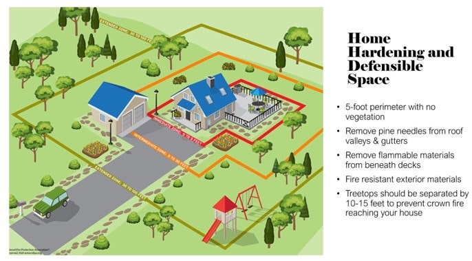
- Create Defensible Space around your house (see Figure below). Defensible space gives firefighters a safer space to operate in while defending your home. Fire experience in the Boulder area (Marshall Fire), as well as other wildfires, shows that creating defensible space makes a big difference in survivability of homes.
HOA Responsibility/Work
HOAs within the District are working on fire mitigation. Genesee Foundation, because it includes so much community-owned Open Space, has budgeted and completed forest thinning for forest health and fire mitigation in its Open Space yearly for 25+ years. Currently, they are prioritizing fire mitigation along evacuation routes (e.g., Genesee Ridge and Vista roads, Foothills North and South, Montane Drive) to enhance survivability during evacuation. In addition, Genesee Foundation funds an annual curbside slash pickup to facilitate and encourage private property owners to do mitigation on their property.
GFPD works with all HOAs to discuss and facilitate fire mitigation efforts.
Genesee Fire Rescue Responsibility/Work
- The 2021 CWPP, funded by GFPD has guided all of the work discussed below.
- In 2021, GFR created a position for and hired a full-time Wildland Specialist. Many initiatives have been completed or are ongoing including the following examples:
o Presentations of the findings of the CWPP, specific to each Plan Unit. These virtual presentations were recorded and available on the GFR website.
o GFR has done, and continues to offer, neighbor walks to discuss wildfire risks and mitigation actions specific to the neighborhood.
o GFR offers free, comprehensive wildfire home evaluations, with suggestions for prioritizing and mitigating areas of risk.
o GFR works with every HOA within the District to encourage fire mitigation efforts. Chimney Creek was recently awarded FireWise status with the help of GFR. A grant submitted by GFR, in cooperation with Chimney Creek, was funded. Mitigation on some of their Open Space will be done this summer...
o GFR has received grant funding for mitigation in an Open Space area that is not part of GFPD, but which poses a significant wildfire risk to GFPD.
o GFR continues its efforts to encourage community emergency preparedness, enhance readiness for emergency operations, and educate its constituents about wildfire risk.
Links to Additional Information:
Where can I find more information about the CWPP?
GFPD Community Wildfire Protection Plan (CWPP)
Where can I find more information about preparing for a wildfire?
Where can I find more information about preparing for evacuation?
Where can I find more information about the Emergency Access Route and supporting documentation?
How can I get more involved with wildfire preparedness?
Most Recent Emergency Access Route Map
